
![]()
Sea Forecasts
Synoptics
Theory
Weather Buoys
Weather Stations
Satellites
UTC
![]()
![]()
![]()
![]()
![]()
Weather
New/Amended links on March 6th, 2014
Forecasts for UK and Ireland Sea Areas
Interesting 'pay-for' sites - with free features
Back in the day, theyr.net hosted very detailed weather information. It was run by a small specialist team in Iceland.
That moved to theyr.tv in 2006.
The sailing section gives detailed (0.2 of a degree) hour-by-hour forecasts in a 72-hour window.
There is a 14-day free trial that is well worth exploring. Short-term or long-term subscriptions are not expensive.
A separate service theyr.com - based in the UK came along in 2008.
Confusion with theyr.net is possible. This is either coincidence or the sincerest form of flattery.
This has free sections for basic weather and graduated levels of subscription cost for increased detail including tidal streams and wave information.
Another favourite for UK and Irish waters
The Sailing section of WeatherOnline has Wind, Surface Pressure, Wave Height forecasts at 3-hourly intervals for up to 7 days ahead. Coverage is by Sea Area.
There are weather reports from coastal stations, with a history for stations.
Satellite Images go back 3 days at 3-hourly intervals.
The big boys
| Met Office In recent years they have moved to the view that they should be more forthcoming with free information. |
BBC Weather Centre (Coast and Sea section) has tides and basic forcasts for inshore, coastal and Atlantic in a nutshell. | |
| Marine Forecast | This has links to good interactive and animated charts. It also has links to text equivalents for those not blessed with high-bandwidth Net connections and/or tiny screens. | As the Met Office has increased and improved on the information it offers, so the BBC has reduced its coverage. Now it's more meh-trology. |
Specific to Ireland
The official Irish Met web presence, http://www.met.ie has a marine section: http://www.met.ie/marine/marine_map.asp This has links to forcast categories and an interactive map with links to buoy reports. It is also useful for 'out-of-town' sailors as it describes the terms used in forcasts, which are different to those used in the UK.
They have two mobile sites:
For smartphones: m.met.ie
For older phones such as those used by myself and Noah: mobile.met.ie
Synoptic Charts
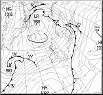 |
Wetterzentrale, at http://www.wetterzentrale.de/
seems to be a happy hunting ground if you read German or are lucky. |
 |
The European Centre for Medium-Range Weather Forecasts (ECMWF) has 3-day to 7-day forecasts at http://www.ecmwf.int/products/forecasts/d/charts/deterministic/world/msl_uv850_z500 |
Theory
Frank Singleton is a Met man who is also a "yottie".
He has information on weather science/theory as well as forecasts.
Weather Buoys
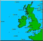 |
Some of the loneliest cans on the planet are indexed vie interative maps at http://www.ndbc.noaa.gov/maps/United_Kingdom.shtmlland.shtml Check the wave heights, wind speeds and temperatures. Be thankful you're not there. |
Weather Stations
A list of reports from weather stations around Ireland (and anywhere else in the world) can be found at http://www.wunderground.com/global/IE.html
Ignore the weather and pay close attention to the advertising. Enjoy the belief that someone else is paying for the technology.
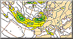
Satellite
University of Dundee Satellite Receiving Station - at http://www.sat.dundee.ac.uk/ receive and publish images from NOAA and SeaStar polar orbiting satellites.
The free registration seems to be a way of delivering free to you things that might otherwise be expensive or unobtainable.
Whine
What none of these sites do is to provide an explanation of why on each of two delivery trips from Cherbourg to Kinsale, the winds have been F6/F7 from the NW in the immediate aftermath of strong gales. Why? Was it something I did/said/didn't? In this life, in a previous life? Why?
UTC
UTC - is a term pasted all over weather charts, and is 'basically' what used to be GMT.
Once upon a time, there was a FAQ at the National Institute of Standards and Technology (NIST) that said:
"Greenwich Mean Time (GMT) is a 24 hour astronomical time system based on the local time at Greenwich, England. GMT can be considered equivalent to Coordinated Universal Time (UTC) when fractions of a second are not important. However, by international agreement, the term UTC is recommended for all general timekeeping applications, and use of the term GMT is discouraged. "
So now you know.
But: Why is "Coordinated Universal Time" referred to as UTC ????
Simple! The English speakers suggested CUT, but the French wanted something, well, more French - so they compromised on something less English.
Props to Robbie
I should thank Robbie for bringing a number of broken links to my attention.
I was guilty of allowing this page to "mature" aka fade for 10 years. Shame at this drove me to do a major cleanup :)
Robbie has a keen interest in weather as related to safety. Here are some related links he offered:
National Weather Service: Safety Resources
http://www.weather.gov/safety
Weather News from Answers.com
http://weather.answers.com/
Disaster & Safety Library | Disaster Preparedness
http://www.redcross.org/prepare/disaster-safety-library
Driving Safely while Dealing with the Elements:
http://kidshealth.org/teen/safety/driving/driving_conditions.html
Driving Your Car in Bad Weather: Tips from the Experts
http://www.kanetix.ca/driving-your-car-in-bad-weather